Introduction
Since 1958 at least 17 discernible tagging studies have been conducted on American plaice (Hippoglossoides platessoides) in Canadian waters of the Northwest Atlantic adjacent to Nova Scotia, New Brunswick and Prince Edward Island. Less than half of these mark: recapture studies have been reported in the literature (only the earliest 1958–1960 experiments). In all cases where objectives are known, discrimination of separable subpopulations as fishery stocks for assessment and management was always foremost. The current paper attempts to synthesize all plaice tagging studies, including those unpublished, conducted west of the Laurentian Channel and east of the Gulf of Maine. Re-analysis of previously published 1958–1960 work (Martin 1959; Martin 1960; Anon 1964; Powles 1965) became necessary to incorporate new recovery information that was not available at the time of the earlier analyses. Existing notions about plaice stock structure relevant to fisheries are revised.
This overview could be pertinent to recovery potential assessments of populations of American plaice, given the recent evaluation of the species in Canadian waters as “Threatened” by the Committee on the Status of Endangered Wildlife in Canada (COSEWIC, 2009). COSEWIC defines two populations, or “Designated Units” (DU), of American plaice. One, the Newfoundland and Labrador DU, comprises plaice around Newfoundland and further north, but not including the Gulf of St. Lawrence. The second is the Maritimes DU, comprising plaice throughout the Southern and Northern Gulf of St. Lawrence (separated by the deep waters of the Laurentian Channel), Scotian Shelf, and Bay of Fundy. Plaice within the Maritimes DU, exclusive of the Northern Gulf of St. Lawrence, are the primary focus of this paper.
Methods
Data Sources
A total of 13 292 American plaice were tagged throughout the Southern Gulf of St. Lawrence, Scotian Shelf and Bay of Fundy between 1958 and 1997. Tag release details of all but the 1997 tagging are given in Stobo and Fowler (2006). The 1997 tagging followed the same protocols established for the 1978–1985 tagging programs documented in Stobo and Fowler (2006).
The focus of the earliest Canadian tagging studies on American plaice in waters west of Newfoundland reflected the large fisheries of the time, concentrating on southern Gulf of St. Lawrence stocks of plaice. These investigations, conducted between 1958 and 1963 as a large-scale tagging program, covered a swathe across the top of the Magdalen Shallows in the Southern Gulf of St. Lawrence (Fig. 1). A total of 1959 plaice were tagged from Chaleur Bay to the Magdalen Islands during May–October, 1958–1960. This was followed by an attempt to cover waters from Sydney Bight through the Cape Breton Trough to the area between St. Georges Bay, New Brunswick and Souris, Prince Edward Island. But only 236 fish were tagged (in October of 1963), and only 19 of these were in or very close to Sydney Bight. These studies were all reported in the secondary literature (Martin 1959; Powles 1959; Martin 1960; Powles 1963; Anon., 1964; Lettaconnoux 1965), with one primary publication (Powles, 1965) discussing the results of the 1958–1960 tagging. Interpretations were based primarily on short-term recoveries (one or two years post-release), a common practice at the time. Appreciable numbers of longer-term recoveries made two or more years post-release were not considered in these accounts of plaice tagging, and these later recoveries have implications not revealed by earlier recoveries. As well, an indeterminate number of recoveries that occurred prior to publications were absent from the earlier studies, likely representing recaptures that were not immediately submitted for rewards (e.g. tag hoarding or collecting).
|
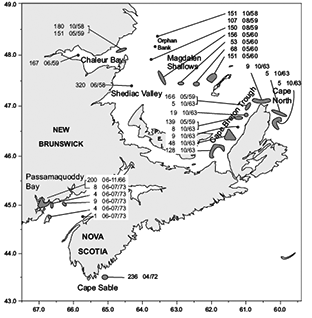
Fig. 1. Locations of tagging releases of American plaice in NAFO Subarea 4 between 1953 and 1973. The numbers of fish tagged and the month/year of release are given for each release location. In many cases several discrete releases of close geographic proximity and/or size range of fish were combined for this composite map.
|
Between 1963 and 1979 no large-scale tagging efforts were directed on American plaice. Some tagging was conducted in the Bay of Fundy and off southwest Nova Scotia, reflecting growth of interest in plaice as commercial prospects outside the Gulf of St. Lawrence. A second large-scale tagging initiative on American plaice was conducted during 1979–1980, and essentially repeated the 1958–1963 exercise in the southern Gulf of St. Lawrence, as well as targeting plaice off Halifax, Nova Scotia. The second tagging program in the Gulf of St. Lawrence was largely inspired by a developing appreciation for the potentially confounding role of short-term recoveries on interpretations of movements. The 1958–1963 tagging was conducted in the midst of the fisheries, such that immediate recoveries from nearby vessels were a large component of reported results. Conversely, during 1979–1980 the locations and timing of tagging operations avoided active fisheries, to ensure opportunity for fish to disperse before recapture. Coupled with historical changes in fisheries for American plaice, these experiments provide some new perceptions about movements and stock affiliation relative to the 1958–1963 studies.
The last large-scale tagging of American plaice occurred in 1997 in Sydney Bight, seeking to confirm if a discrete non-migratory population of American plaice was exclusive to the local waters of the Bight.
The first of the unpublished tagging studies (Fig. 2) were small-scale endeavours. In 1966, 200 plaice were tagged in Passamaquoddy Bay at the head of the Bay of Fundy, and another 26 fish were tagged mostly outside but near Passamaquoddy Bay in 1973. In 1972, 236 plaice were tagged near Cape Sable, Nova Scotia.
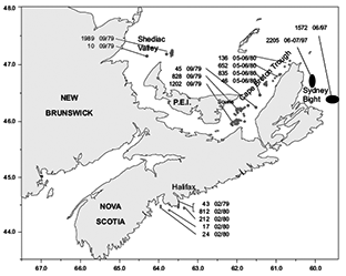
Fig. 2. Locations of tagging releases of American plaice in NAFO Subarea 4 between 1978 and 1997. The numbers of fish tagged and the month and year of release are given for each release location. In many cases several discrete releases of close geographic proximity and/or size range of fish were combined for this composite map.
|
In 1979–1980 a phase of large-scale tagging activity on American plaice occurred during February off Halifax, Nova Scotia (1108 fish), September tagging of 4074 fish off both ends of Prince Edward Island, and May–June tagging of 1669 fish in the northern portion of the Cape Breton Trough. The locations and timing of the tagging operations were chosen to isolate assumed or speculated populations, based on results of the 1958–1963 program, while at the same time avoiding active fisheries on plaice. This may have been achieved to a large extent, but no formal documentation could be found to indicate success or failure in this regard. Anecdotal information suggests that some to all of the May–June tagging in the Cape Breton Trough might have been conducted on plaice that were physiologically spent from recent spawning.
The last tagging study of American plaice in Canadian waters south of Newfoundland was conducted in June–July of 1997, when 3777 plaice were tagged in Sydney Bight. It was assumed that if a stationary, locally resident population of plaice existed in Sydney Bight, summer tagging might discern them from Gulf of St. Lawrence plaice, assuming Gulf plaice only co-habited the Bight during winter months.
Processing and Analysis
Release and recovery data for all the studies treated in this paper was preserved over the years, and is currently maintained as a SQL database. The systematic nature of tag-recovery programs conducted by the Maritimes Region of the Department of Fisheries and Oceans ensured that recoveries were processed regardless of their perceived relevance at any given time by specific researchers. Recoveries from tagging studies considered to be completed investigations continued to be logged in the same manner as previous recoveries. Thus we have all the data available to earlier researchers, as well as that for recoveries made subsequent to previously published analyses.
Preliminary analyses of the recoveries from the various releases were conducted independently on subgroups of the releases distinguishable by any difference in year/month of tagging or geographic discontinuities in tagging locations. Where tagging subgroups were proximate in timing and location of release and demonstrated compatible patterns of recoveries, they were combined to produce the 17 release groups defined in Table 1. These groups were intended to provide appropriate discrimination among tagging events to discern any differences in movements between potential subpopulations.
Most plaice tagged in the studies presented here were measured. Length of fish when tagged can have ramifications for subsequent movements and survival. Inclinations to migrate may not occur until maturation, and long periods of natural mortality may be sustained by smaller fish prior to recruitment to fisheries. Female plaice length at maturity (L50) differs by region and has generally declined over time (Beacham, 1983; COSEWIC, 2009). For this study we broadly label mature fish according to typical female L50’s as 41 cm or larger for tagging before 1970, and 31 cm or larger for later studies. Approximate ages were determined from length at release to investigate long-term trends in dispersal.
Recoveries from each release group exhibiting recapture locations of sufficient detail to pinpoint the recovery to within a NAFO/ICNAF Statistical Unit Area were plotted by month to portray seasonal movements. The precision of the recovery data, specifically possession of navigation technology adequate to provide Loran or Cartesian coordinates, can be non-randomly associated with geographically and temporally discrete fishery components. This was of particular concern in the earlier studies, where recovery information could be disregarded if location coordinates were not provided. In this analysis, where precise location data (latitude, longitude) were unavailable but Unit Area was reported, the overall mean recovery location of tags within the Unit Area was substituted. Tags reported only to the detail of NAFO Division were not plotted, but instead were tabulated on land or offshore regions of recovery plots.
Plotted recoveries were distinguished with respect to time at large as short-term (under a year), medium-term (over a year, under three years), and long-term (three or more years) to reduce the contribution of shorter-term recoveries to interpretations and enhance that of longer-term recoveries to discern redundancy in movement patterns over years, and discriminate long-term dispersal.
Recoveries were not weighted by commercial fishing effort. Most of the tagging studies investigated here were conducted between 1958 and 1980, years for which most of the commercial fishing effort was either not yet available or generalized geographically beyond a useful scale for weighting tag recoveries. Commercial landings data was tabulated by year since 1960 to whatever seasonal and spatial detail could be achieved, and this information aided in interpretation of recovery data for later years. Reported landings to the North Atlantic Fisheries Organization (NAFO) were used to cover 1960–1985, but summarize catches to broad-scale NAFO Divisions, which is inadequate to represent spatial effort patterns relevant to American plaice, especially in the Gulf of St. Lawrence. Summaries of regional landings in the southern Gulf of St. Lawrence were obtained for 1979–1983 (Rod Morin, DFO Science, Gulf Fisheries Centre, Moncton, NB, Can, pers. comm.), and used qualitatively to aid interpretations of tag recoveries. Since 1986 we have commercial landings reported to the International Commission of Northwest Atlantic Fisheries (ICNAF) at the finer scale of ICNAF Unit Areas (Fig. 3), adequate to represent spatial effort patterns, but too late for all but the 1997 Sydney Bight tagging. Commercial landings since 1992 have been adjusted for species identification problems (Fowler and Stobo, 1999; Fowler and Stobo, 2000). Deciphering recovery patterns for the 1958–1963 tagging relied heavily on descriptions of the fisheries provided in annual reports of the Fisheries Research Board of Canada. By the time of the 1979–1980 tagging, stock assessments of commercial fish provided sufficient background on the geographic and temporal concentrations of fishing effort for our purposes.
|
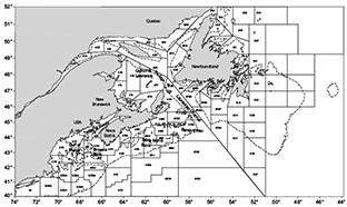
Fig. 3. Map of the northwest Atlantic, showing ICNAF unit area boundaries referred to in this report. Major topographical zones are delineated by 200 m depth contours (dashed lines).
|
Results
Earliest Tagging Studies 1958–1963
Southern Gulf of St. Lawrence North of Prince Edward Island
(Tagging Groups: Shediac Valley, June, 1958; Orphan Bank, October, 1958 and August, 1959; Chaleur Bay, October, 1958 and May–June, 1959)
Almost all of the recoveries from the more northern tagging studies were made within the Gulf of St. Lawrence fishing season between May and December in the general vicinity of the tagging locations, with no recoveries between January and April (Fig. 4). This reflects the location and timing of fishing, as there was no winter fishery for plaice in or around the Gulf of St. Lawrence during this time period. The June recovery from the edge of the Laurentian Channel was made in 1960. The recovery from the Magdalen Islands near the edge of the Laurentian Channel in July occurred in 1961, and that from 4Rd (southwestern tip of Newfoundland, across the Laurentian Channel) in April of 1965. One recovery was reported from 4S in 1960 with no information as to month or unit area of recovery.
|
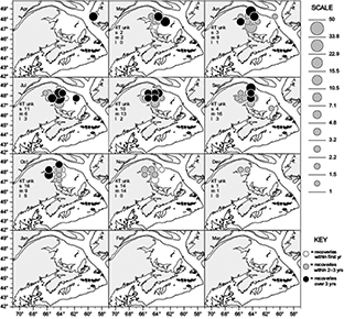
Fig. 4. Recoveries from American plaice tagged around Shediac Valley during June of 1958, on Orphan Bank during October of 1958 and August of 1959, and in or near Chaleur Bay during October of 1958 and May‒June of 1959. Tags are aggregated over five minute squares as scaled circles, the size of the circle proportional to the number of recoveries. Tags at large less than one year are plotted as open circles, tags at large 1‒3 years as grey circles, and longer-term recoveries as black circles. Unplottable tags with months and locations known to NAFO Subarea are tabulated as short (s), medium (m) or longterm (l) on applicable graphs.
|
Gulf of St. Lawrence South of the Magdalen Islands
(Tagging Groups: Cape Breton Trough, May, 1959 and October, 1963, and Cape North, October, 1963)
Most recoveries from these groups were made around the tagging area during the spring and fall Edge fisheries (Fig. 5; the Edge refers to the abrupt increase in depth along the Laurentian Channel) that target overwintering plaice leaving from or returning to the southern Gulf shoals. Recoveries from the tagging area show redundancy over the years, and most of the recoveries from 1963 tagging occurred after the last published accounts. They associated strongly with the tagging area during the summer, with a shift toward the Lip (a protruding edge of the Laurentian Channel near Cape North, Fig. 3) in spring and fall. The Lip recoveries were most pronounced in the spring.
|
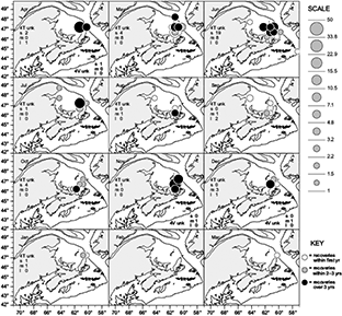
Fig. 5. Recoveries from American plaice tagged in the Cape Breton Trough during May of 1959 and October of 1963, and off Cape north in October of 1963. Tags are aggregated over five minute squares as scaled circles, the size of the circle proportional to the number of recoveries. Tags at large less than one year are plotted as open circles, tags at large 1‒3 years as grey circles, and longer‒term recoveries as black circles. Unplottable tags with months and locations known to NAFO Subarea are tabulated as short (s), medium (m) or longterm (l) on applicable graphs.
|
None of the recoveries outside the tagging area were accounted for in the literature. The June recovery on Banquereau occurred the month following tagging. Such a long distance in such a short time is unlikely. The August (one fish) and September (three fish) recoveries from the Chaleur Bay area were made in their 1959 tagging year, suggesting they might have been considered and disregarded in earlier analyses, but without tag receipt dates uncertainty remains. Reaching Chaleur Bay in a couple of months would not be an unreasonable movement for overwintering plaice returning to the Gulf. The two July recoveries from the Chaleur Bay area, also not accounted for in the literature, were recoveries in 1961 from 1959 tagging.
Magdalen Shallows, May, 1960
Recoveries from this group were prominent from a number of fisheries (Fig. 6). They featured strongly in the spring Edge fisheries along the Laurentian Channel, with a major concentration off the Magdalen Islands, and another off the Gaspé Peninsula where the Channel edge comes closest to land. In the summer they showed up strongly in both the Chaleur Bay area and in the vicinity of tagging around the Magdalen Islands. Returns favoured the Chaleur Bay area during the fall. By December–January we only had recoveries from the vicinity of Cape North at the entrance to the Gulf of St. Lawrence (border of 4T and 4Vn). No recoveries were made in February–March. Returns from the Cape North area became proportionately more important after 1961, the last year considered in published accounts (Powles, 1965).
|
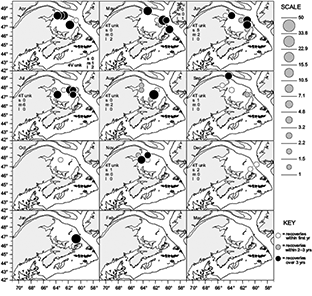
Fig. 6. Recoveries from American plaice tagged on the Magdalen Shallows during May of 1960. Tags are aggregated over five minute squares as scaled circles, the size of the circle proportional to the number of recoveries. Tags at large less than one year are plotted as open circles, tags at large 1‒3 years as grey circles, and longer‒term recoveries as black circles. Unplottable tags with months and locations known to NAFO Subarea are tabulated as short (s), medium (m) or longterm (l) on applicable graphs.
|
Recoveries from the Magdalens shallows tagging continued for some time after any reference was made to them in the literature. Spring returns from 4V recurred over subsequent years, and a recovery was reported from each of 4Sy (Quebec side of Anticosti Island) and 3P (Newfoundland side of the Laurentian Channel south of Cabot Strait), both in May of 1964.
Unreported Tagging Studies 1966–1997
Passamaquoddy Bay, Inside, June-November, 1966 and Outside, July, 1973
Initially recoveries from the 1966 group were localized to the tagging area, but starting in November, 1967 they began occurring from areas directly south, outside the Bay of Fundy as far as Browns Bank on the Scotian Shelf (Fig. 7)
|
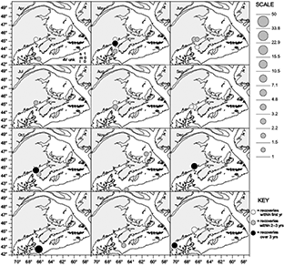
Fig. 7. Recoveries from American plaice tagged in Passamaquoddy Bay during June‒November, 1966, and just outside Passamaquoddy Bay in July, 1973. Tags are aggregated over five minute squares as scaled circles, the size of the circle proportional to the number of recoveries. Tags at large less than one year are plotted as open circles, tags at large 1‒3 years as grey circles, and longer-term recoveries as black circles. Unplottable tags with months and locations known to NAFO Subarea are tabulated as short (s), medium (m) or longterm (l) on applicable graphs.
|
The 1973 group provided only three recoveries, and only one of these is plotted (it came from across the Bay of Fundy in October of 1974). A second tag was reported from the Jeffery Ledge area far to the west (near Portland, Maine) four years after tagging. Although anomalous, it is not implausible. The third tag lacked recovery information.
Cape Sable, April, 1972
These fish stayed very local to the tagging area (Fig. 8), only one fish travelling far enough to leave 4Xo (recovered a little to the east in 4Xm). This impression is reinforced by consistency in locations of recaptures over successive years.
|
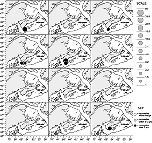
Fig. 8. Recoveries from American plaice tagged off Cape Sable during April of 1972. Tags are aggregated over five minute squares as scaled circles, the size of the circle proportional to the number of recoveries. Tags at large less than one year are plotted as open circles, tags at large 1‒3 years as grey circles, and longer-term recoveries as black circles. Unplottable tags with months and locations known to NAFO Subarea are tabulated as short (s), medium (m) or longterm (l) on applicable graphs.
|
Shediac Valley, September, 1979
Successfully avoiding fisheries during the tagging process, the first recoveries from this group are the two November (1979) fish seen in the Chaleur Bay and Magdalen Shallows areas two months after tagging (Fig. 9). Other than these two fish, there were never any recoveries from October through March, even though recoveries from this group were plentiful and lasted for six years post-tagging. They showed up in the Lip, Edge, Magdalen Shallows, Chaleur Bay and Shediac Valley fisheries in the spring and early summer. By July recoveries were concentrated in the Shediac Valley area where the fish were tagged. Returns were scarce from the area between Prince Edward Island and Cape Breton, which featured pronounced fishing on plaice throughout spring, summer and fall of 1979–1983 (Table 2).
|
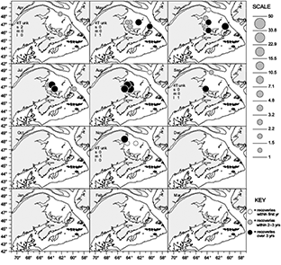
Fig. 9. Recoveries from American plaice tagged around Shediac Valley during September of 1979. Tags are aggregated over five minute squares as scaled circles, the size of the circle proportional to the number of recoveries. Tags at large less than one year are plotted as open circles, tags at large 1‒3 years as grey circles, and longer‒term recoveries as black circles. Unplottable tags with months and locations known to NAFO Subarea are tabulated as short (s), medium (m) or longterm (l) on applicable graphs.
|
Souris, September, 1979 and Cape Breton Trough, May–June, 1980
Fall tagging largely avoided active fisheries during Souris tagging operations, only 15 of the 200 recoveries from the Souris group occurring in the tagging year. The next recoveries from Souris fish start in April of 1980 and continue through 1987. The Trough tagging was immediately subject to active fishing, with a third of the recoveries occurring in the tagging year, but provided good returns through 1985. Recoveries of Souri and Trough fish exhibited a pattern of shifting their concentration from the Lip area in the spring to the Trough in the summer, back to the Lip in the fall, then with some Laurentian Channel recoveries in the Sydney Bight area in November–December (Fig. 10). We never saw a recovery inside the Gulf during the typical period of sea ice formation from January to March. Nor did they appear in the Shediac Valley or Chaleur Bay fisheries, which were very active from May through September of 1980–1983 (Table 2). Two returns were reported from the southern coast of Cape Breton on the Scotian Shelf in September and November. In later years some of these fish were reported from Banquereau. A single August recovery on Browns Bank off southwest Nova Scotia occurred little over a year post-release. Such a long distance (over 400 miles) in such a short time seems unlikely.
Halifax, February, 1979 and 1980
Most of these fish were recovered locally, with a few moving offshore to Sable Island Bank (Fig. 11).
Sydney Bight, June–July, 1997
Recoveries from these fish were concentrated in the tagging area in every year from 1997 through 2000. Many were also taken by the Lip fishery throughout spring, summer and fall (Fig. 12). Small numbers were reported from near the Magdalen Islands and in the Cape Breton Trough during the summer, and from Banquereau in the fall. The only recovery during the months of December through April was a February report from 3Pd, directly across the Laurentian Channel from Sydney Bight.
|
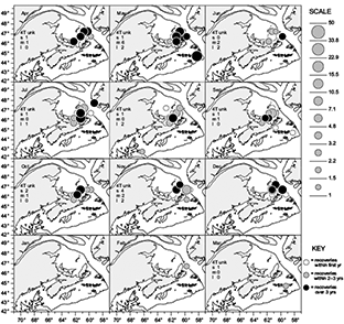
Fig. 10. Recoveries from American plaice tagged near Souris during September of 1979, and in the Cape Breton Trough during May‒June of 1980. Tags are aggregated over five minute squares as scaled circles, the size of the circle proportional to the number of recoveries. Tags at large less than one year are plotted as open circles, tags at large 1‒3 years as grey circles, and longer-term recoveries as black circles. Unplottable tags with months and locations known to NAFO Subarea are tabulated as short (s), medium (m) or longterm (l) on applicable graphs.
|
Discussion
General
Interpreting results across widely disparate time periods, differing objectives, and changes in tagging strategies and methods, posed some considerations that have been addressed in earlier work and warrant some mention here. Tag recovery rates were much higher in the earliest years for all tagging studies, regardless of species. For plaice in the Southern Gulf of St. Lawrence about 41% of the tags attached during 1958–1963 studies were returned, while only about 7% of those applied during 1979–1980 studies were returned. Changes in the commonest tag types used, from Petersen discs prior to 1979, to T-bar anchor (spaghetti) tags since that time, would not have altered recovery expectations to the extents observed (Fowler and Stobo, 1991). In general, for all species the decline was attributed as likely due to increasing automation in the processing of catches over time, coupled with decreasing inclination of the fishing industry by the late 1970s to return tags without knowing how the information might influence fishery management decisions (Fowler and Stobo, 1999). That recovery rates for plaice were among the most extreme examples of declines over time indicate a further effect of tagging strategy, the deliberate avoidance of active fisheries during the 1979–1980 tagging operations (i.e. the September 1979 Shediac Valley and Souris tagging, the February 1979 and 1980 Halifax tagging). Short-term recovery rates of plaice from earlier tagging studies greatly exceeded those of the 1979–1980 tagging, while conversely long-term recovery rates from the 1979–1980 tagging exceeded those of the earlier tagging (Stobo and Fowler, 2006). Thus much of the difference in recovery rates for plaice between time periods is attributable to large proportions of recoveries that were temporally proximate to the tagging operations during the 1950s and 1960s.
|
Fig. 11. Recoveries from American plaice tagged near Halifax during February of 1979 and 1980. Tags are aggregated over five minute squares as scaled circles, the size of the circle proportional to the number of recoveries. Tags at large less than one year are plotted as open circles, tags at large 1‒3 years as grey circles, and longer-term recoveries as black circles. Unplottable tags with months and locations known to NAFO Subarea are tabulated as short (s), medium (m) or longterm (l) on applicable graphs.
|
|
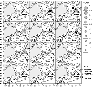
Fig. 12. Recoveries from American plaice tagged in Sydney Bight during June‒July of 1997. Tags are aggregated over five minute squares as scaled circles, the size of the circle proportional to the number of recoveries. Tags at large less than one year are plotted as open circles, tags at large 1‒3 years as grey circles, and longer-term recoveries as black circles. Unplottable tags with months and locations known to NAFO Subarea are tabulated as short (s), medium (m) or longterm (l) on applicable graphs.
|
The length of a plaice when tagged has been shown to be related to subsequent probability of recovery, with smaller fish giving lower recovery rates (Fowler and Stobo, 1999). The chances of recovering fish under about 36 cm are especially problematic. Generally a wide size range of fish were tagged in all releases in the studies considered here (between 10–69 cm with a single fish at 86 cm), the majority being between 23–55 cm. Most groups with appreciable numbers of plaice under 36 cm are also characterized by substantial numbers of larger plaice as well. The 1979–1980 tagging of plaice off Halifax had the largest proportion of fish under 36 cm (about 80%), likely contributing to the low recovery rate of 4.9% for this group. Within the few 36+ cm fish of this group the recovery rate was 21%.
Southern Gulf of St. Lawrence
The Canadian Research Report for 1958 reported 27% of tags recovered from June tagging in northern 4T (Martin, 1959), likely reporting on returns within the first year. The final recovery rate, unreported, was 42%. The Canadian Research Report for 1959 reported recoveries of 37% per year in the Shippegan Gully area (lower mouth of Chaleur Bay) where concentrated fishing occurred in May–June (Martin, 1960). The Canadian Research Report for 1964 (Anon., 1964) reported that the study of American plaice in the Magdalen Shallows (shoal area between Chaleur Bay and the Magdalen Islands) was completed in 1963, concluding that two groups of plaice were present in the southwestern Gulf – a northern group in 4T (in and around Chaleur Bay) and a southern group in 4T/4V (Magdalen Islands/Sydney Bight). No details of temporal patterns in movements were provided. It is unclear if the 1963 Cape Breton Trough and Cape North tagging studies were considered.
This analysis of all tagging studies in the Gulf of St. Lawrence combined (Fig. 13) also distinguishes the two subpopulations of plaice mentioned above, a southern group (Souris, Cape Breton Trough) and a northern group (Chaleur Bay, Shediac Valley, Orphan Bank). The region of the Magdalens Shallows near the Magdalen Islands seems a mixing area, demonstrating differing affiliations with northern and southern groups among tagging studies. From summer through fall, the northern group concentrates in waters encompassed by Prince Edward Island, Chaleur Bay, the Laurentian Channel, and the Magdalen Islands, while the southern group concentrates in the Cape Breton Trough area from Souris to Cape North. There appears to be a similar north/south separation during overwintering in the Laurentian Channel. Spring and late fall recoveries from southern studies were prevalent in the Lip fisheries (the protuberance in the Channel edge off Cape North), and winter recoveries were reported from the Sydney Bight area. Recoveries from northern studies are conspicuously absent or rare from the Lip fishery, and we never got an overwintering recovery from any of the northern groups of plaice (no recoveries were ever reported for January–March), suggesting they overwintered somewhere fishing did not occur, which would have been anywhere northwest of the Magdalens. Spring and fall tag returns from the northern studies may suggest the northern edge of the Channel near the Gaspe Peninsula might be the route of return, but this could be an artifact of lack of fishing effort along the edge of the Channel anywhere else north of the Magdalen Islands. Tallman (1991) also inferred that northern and southern Gulf plaice maintained a north-south orientation when overwintering in the Channel, postulating migratory routes perpendicular to the Channel based on relative distributions of size at age between areas. Concentrations of plaice in the Laurentian Channel near the Gaspe Peninsula are also evident from a November 1990 groundfish survey of the southwestern Gulf (Fig. 32b of Darbyson and Benoit, 2003).
|
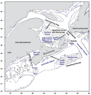
Fig. 13. Schematic portrayal of known and putative populations of plaice and principle movement patterns. Depth contours are at 100 m and 200 m.
|
Identification of two discrete groups of Gulf of St. Lawrence plaice concurs with the results of Powles (1965) investigation of the 1958–1963 tagging studies in the Gulf. Powles concluded northern and southern groups with no extensive movements by either group much beyond 4T. Lack of recoveries in the area between Prince Edward Island and the Magdalens is attributed to the rocky nature of the bottom, as plaice prefer sand/mud substrate. Although a 1965 paper, Powles only discusses the 1958–1960 tagging in any detail, and only through 1961 recoveries. Subsequently there were recoveries every year through 1969, with the last recovery in 1978. Powles mentions the 1963 tagging (George Bay), and notes mixing with North Bay (Cape Breton Trough) plaice but none with northern 4T plaice, but does not present results as for the earlier tagging. Powles did not discuss overwintering locations or migration routes for these fish, and stated that interpretation of seasonal movements was confounded by the virtual absence of a fishery in winter. In Chaleur Bay fishing began in June and ended in November, while offshore and Magdalen Islands landings peaked in early summer and again in the fall. In later years the seasonal pattern to fishing effort underwent transition to favour stronger spring and fall Lip/Edge fisheries, a shift in effort reflected in the seasonal pattern of recoveries between time periods (Table 3). This probably denotes the greater offshore/weather durability and mobility of fishing effort in the more recent period, such that more effort could be directed on migratory concentrations in earlier and later months than previously. It may also reflect changing capabilities to fish at depth, as many of the plaice leaving for or returning from overwintering in the Laurentian Channel would be associated with greater depths than typically occupied on the shoals of the Gulf. A series of groundfish surveys conducted in the Channel during 1994–1996 depicted the depth and temperature preferences of plaice in January (Swain et al., 1998), showing that overwintering plaice were rarely found shallower than 250 m, as compared to favouring depths well above 100 m in September.
Longer-term recoveries of the early Gulf studies that occurred after any published accounts offer some insight on the potential of older fish to migrate longer distances. Table 4 summarizes the proportions of fish by age, approximated from length at release then adding years at large, exceeding the mean overall distance of recoveries (28.3 nautical miles) from their tagging locations. Results are tabulated by month to account for seasonal biases due to overwintering migrations of all ages to and from the Laurentian Channel. Older fish are generally recovered from more distant locations than younger fish, and the tendency to wander farther may be a continuous function of age (or size), as opposed to a simple change in behavior with maturity. The A50 of plaice in earlier studies was around 6/10 male/female, declining to around 4/6 by the time of the Sydney Bight tagging (COSEWIC, 2009), so the later studies may not offer contrast between juveniles and adults.
Sydney Bight
An overwintering association between southern Gulf of St. Lawrence plaice and Sydney Bight (4Vn) was not discussed by Powles (1965). Assuming a cut-off date of 1961 to past analyses of recoveries from 1958–1960 studies, returns from outside the Gulf might have been too few to interpret comfortably. As well, there was no concern about the status or identity of Sydney Bight plaice at that time as there is today. Prior to 1963 Canadian fisheries anywhere in 4VW showed little interest in American plaice, while the Gulf of St. Lawrence supported a major fishery before any tagging studies were initiated (Fowler, 2012). Thus in 1965 when Powles reviewed the tagging results in light of fishing effort, 4Vn may not have been perceived as relevant to plaice fisheries. 4T plaice landings reported to NAFO during 1961–1965 were roughly two orders of magnitude higher than those from winter fishing in 4Vn. If we consider post-year-of-release recovery rates in 4T as proportionate to landings (effort), then winter landings of plaice in 4Vn were much too low to expect recoveries of any plaice overwintering there. Notably, Powles (1965) summarizes plaice landings for 1959–1961 to gauge ramifications of effort on expectations of recovery, yet only has headings for 4T areas, with no mention of any fishing in 4Vn.
By the time of the 1979–1980 tagging, fishing for plaice in 4Vn was well-established, with plaice subjected to quota management since 1974. Recoveries of southern 4T plaice (Trough and Souris tagging) in 4Vn became fairly common, and even a couple of northern 4T plaice were reported from 4Vn 3–4 years post-tagging. The general proportion of 4Vn recoveries increases with time post-release, and although showing some seasonal (spring and winter) bias, several show up as summer recaptures. Bight/Shelf recoveries from the 1979 Souris tagging were between 8 and 9% of total recoveries in 1980, but 24% of total recoveries for 1981–1987 combined. Similarly Bight/Shelf recoveries from the 1980 Trough tagging were 4% in 1980 and 25% for later years combined. This would fit with Powles (1965) observation that older fish show more mobility, it just appears more pronounced after plaice-directed fishing effort in 4Vn became common. This is also reflected in trends of increasing mean distance of recoveries from 4T tagging locations with time at large (Table 5). Distances are generally more pronounced for 1979–1980 tagging studies relative to the 1953–1963 tagging studies, as proportionately more recoveries came from outside the Gulf of St. Lawrence in the later period.
When the summer 1997 plaice tagging in 4Vn itself was conducted, there was little plaice fishing in 4T due to a cod moratorium. The 4T plaice TAC had been 10 000 t from 1978 until 1993, when it was halved to 5000 t. Then in 1996 it was reduced again to 2000 t, which has been the average TAC since that time. Most of the plaice caught in 4T since the closure of the cod fishery in 1993 have been taken in the eastern Gulf in Unit Areas 4Tf and 4Tg (Morin et al., 2001). From 1997 through 2003 the 4VW TAC on all flatfish was 3000 t, of which plaice were typically about a third of the catch, a similar order of magnitude of effort to 4T. We see few recoveries of Sydney Bight tags outside the Bight, with only around 2% of total recoveries coming from 4T, suggesting that the plaice resident in Sydney Bight during the summer are largely distinct from 4T fish. As with the Souris and Trough groups tagged in 1979–80, the Bight plaice show an increasing proportion of distant recoveries with time (e.g. relative Gulf recoveries doubled from 1.4% in 1998 to 2.8% in 1999), which could reflect either a greater tendency to disperse with age or a higher mortality rate in the tagging area relative to adjacent waters
The 1997 Sydney Bight tagging was informative, although recovery patterns may be somewhat confounded by lack of effort in historical fishing areas. We saw strong returns from the inner Bight area from May through November, as well as from the spring and fall Lip fisheries. However if these fish went deeper into the Gulf of St. Lawrence than observed, we still would not expect to see many recoveries from the western Gulf. The formerly strong fishery for plaice in the vicinity of Chaleur Bay went into sharp decline during 1992–1993, and fishing effort directed toward plaice has remained in the eastern Gulf since that time (Morin et al., 2001). Nor might we expect to see recoveries from fish that moved south to Scotian Shelf waters, as landings of plaice from 4VsW almost ceased in 1993 due to moratorium regulations on cod and haddock. The magnitudes of effort in pertinent areas during 1997–2002 suggest weak prospects for recoveries beyond eastern Gulf of St. Lawrence waters and Sydney Bight. Over half the recoveries are known to be attributable to just five boats (one the tagging vessel), and the proportions taken by these five boats remained high over all years but the last (0.55 in 1997, 0.46 in 1998, 0.69 in 1999, 0.80 in 2000, 0.50 in 2001, 0 in 2002). Most of the tags were recovered within the first three years. Of the few tags recovered from the Gulf of St. Lawrence (seven fish) and across the Laurentian Channel in Newfoundland waters (two fish), six of the seven Gulf recoveries could be substantiated.
We saw three successive years post-tagging of strong July–September returns from inner Sydney Bight waters. These are months for which southern Gulf plaice tagged in earlier years were conspicuously absent from Sydney Bight, and fishing effort was sufficient to expect recoveries of available plaice throughout all areas during the period of the 1979–1980 tagging studies. This demonstrates that the plaice resident in Sydney Bight during the summer are discrete from the southern Gulf of St. Lawrence plaice. However it provides no insight on whether they are also discrete from the subpopulation centred on Banquereau.
Scotian Shelf and Bay of Fundy
Tagging information for Scotian Shelf and Bay of Fundy plaice derives entirely from inshore tagging studies, with no tagging of plaice on Banquereau, the densest concentration of plaice on the Shelf (Halliday, 1973; Scott, 1976). Returns from the inshore tagging suggest an inclination for the fish to eventually head offshore, but it does not look like a seasonally repeated movement. It appears to be a mix of random dispersal and directed movements towards preferred spawning and feeding grounds - Browns Bank for plaice tagged in the Bay of Fundy, Sable Island Bank for plaice tagged near Halifax. The Browns Bank recoveries are especially interesting, as we have little more than historical fishery anecdotes to suggest that Browns Bank may have supported a discrete subpopulation of plaice in the past. We know from studies of mature female distributions (Neilson et al., 1988) and the distributions of eggs and larvae (Nevinsky and Serebryakov, 1973) that it stands out as a likely spawning area, which might infer a locally resident population. If so, plaice in the Bay of Fundy may originate from drift of Browns Bank spawning. Then as the fish grow and mature they become motivated to return to the spawning ground.
Synthesis
The plaice currently defined as the Maritimes Designatable Unit by COSEWIC consist of three major known populations and two possible minor populations (Fig. 13). Gulf plaice show strong preferences over time for their original northern or southern affiliation, in terms of both summer feeding grounds and overwintering grounds. They mix to some extent in the spring on the spawning grounds of the Magdalen Shoals, but maintain their population coherence with limited crossover. Considering only recoveries that can be clearly distinguished by Unit Area as north (4Tl, 4Tk, 4Tl) or south (4Tg), all northern tagging groups combined produced 373 recoveries, of which only one came from 4Tg. And of 311 north-or-south recoveries from all southern tagging groups combined, eight (3%) came from 4Tkln.
|
Fig. 13. Schematic portrayal of known and putative populations of plaice and principle movement patterns. Depth contours are at 100 m and 200 m.
|
Banquereau and Sable Island Bank together represent the centre of concentration of Scotian Shelf plaice, serving as both spawning and feeding grounds. As they have never been tagged on these grounds, we don’t know how they might disperse, we can only see that inshore plaice tagged in adjacent areas will move offshore to them.
Sydney Bight plaice show a localized preference for the tagging area, and limited mixing with Gulf plaice. Of 707 recoveries, only seven came from the Gulf, and five of these were close to the border of 4Vn. We don’t know, however, if Sydney Bight plaice are discrete from Banquereau plaice.
Spawning on overfished Browns Bank may be the primary source of plaice for the Bay of Fundy and waters off southwest Nova Scotia, but they could also derive from long-distance dispersal of Banquereau/Sable Island Bank larvae. The marginal abundances of plaice in 4X are equally supported by either hypothesis. Offshore movements of Bay of Fundy plaice in the direction of Browns Bank might argue for Browns Bank spawning as a source of 4X plaice, but this need not be exclusive of western Shelf spawning as a source.
Conclusions
The possibility of long-term dispersion beyond stock boundaries suggested by plaice tagging might promote genetic mixing among populations of plaice, and offer some potential for recolonizing depleted areas. COSEWIC (2009) regards Gulf of St. Lawrence and Scotian Shelf plaice as belonging in the same Designatable Unit, with the caveat that they may be distinct populations (risk indices were calculated separately for the two components). As Gulf plaice are in greater jeopardy than Shelf plaice (rates of adult population decline over three generations of 92% in the Gulf versus 77% on the Shelf), prospects for recovery potential indicated by the tagging studies work in the wrong direction. The current evidence only demonstrates substantive movements of Gulf plaice to the Scotian Shelf, and not from the Scotian Shelf to the Gulf.
Sydney Bight plaice are our only example of movements into the Gulf from anywhere outside, and the identity of this component is in question. If Sydney Bight plaice are a discrete population, they are too few to consider as offering recovery prospects for the Gulf. As well, in contrast to the long-term trends of declining tag recovery rates observed for plaice, and several other species of fish as well (Stobo and Fowler, 2006; Fowler and Stobo, 1999), about 25% of the Sydney Bight tags applied in 1997 were recovered. By today’s standards that is a very high recovery rate, suggesting a high exploitation rate. Thus if Sydney Bight plaice are a discrete spawning component, the recovery rate may represent an unsustainable level of fishing mortality, and they could be in a worse state than the Gulf plaice. However if the plaice in Sydney Bight are marginal to the general population on the Scotian Shelf, this need not have implications for population status, it would just be local depletion.
The centre of concentration of plaice on the Scotian Shelf, Banquereau, has never been addressed by a tagging study, so it is not known how closely related these fish are to Sydney Bight plaice, or how they might contribute to recovery potentials of Gulf (or eastern Shelf) plaice. Further confounding attempts to predict recovery potential, the association between dispersal distance and age (Tables 4 and 5), coupled with the general loss of older fish across all major stocks of plaice (Busby et al., 2007), would reduce likelihoods of movements between areas today relative to those observed in the past. At present, without knowing the movements of Banquereau plaice, it might be safest to assume larval survival and dispersal is more critical to recovery potentials than adult dispersal, at least in the short term, and protecting the spawning grounds could be pivotal to recovery of plaice populations.
Magdalen Shallows plaice mostly spawn mid-April to mid-May (Powles, 1965), a very brief spawning peak compared to plaice outside the Gulf of St. Lawrence. The timing of the spring return of Gulf of St. Lawrence plaice, reflected in monthly patterns of recovery rates (Table 3), coincides with that of spawning. This might imply that proportionately more of the population is available for reproduction in the Gulf of St. Lawrence than other populations of plaice. The short duration of the spawning period could facilitate spawning period/area closure to protect or enhance Gulf plaice.
On the Scotian Shelf spawning is protracted over several months, and we see no evidence from tagging of tightly-timed migrations to spawning grounds, just a general affinity of plaice for such areas at all times. The spawning grounds and the centres of abundance on the Shelf are synonymous, so directed movements to spawn are not critical to the population. A discrete Browns Bank spawning component, if it indeed did and still does exist, would be more vulnerable, and would likely require low fishing pressure over a fairly long period of time to re-establish a sustainable population.
A pervasive problem across all the tagging studies on plaice are temporal/spatial gaps in the possible occurrence of recoveries. As all the tags used in these studies require that the fish be captured, we can perceive their movements only where fisheries are sufficiently prevalent. We cannot address movements of plaice in unfished areas (fishery undeveloped or under moratorium for an area). Today both Gulf and Shelf waters encompassing the largest concentrations of plaice are under fishery moratoriums or strictures that would confound the ability of capture tagging studies to determine movements. Newer satellite and acoustic tag technology, if sufficiently miniaturized, could be useful for filling in these gaps. When that occurs, the centre of abundance for Scotian Shelf plaice on Banquereau should be a top priority for investigation to determine their long-term affinities with Sydney Bight and Gulf of St. Lawrence plaice.
References
ANON. 1964. Canadian research report, 1964. B. Subarea 4. ICNAF Ann. Proc. 14, Part III: 39 p.
BEACHAM, T. D. 1983. Variability in size and age at sexual maturity of American plaice and yellowtail flounder in the Canadian Maritimes region of the Northwest Atlantic Ocean. Can. Tech. Rep. Fish. Aquat. Sci. 1196: 75 p.
BUSBY, C. D., M. J. MORGAN, K. S. DWYER, G. M. FOWLER, R. MORIN, M. TREBLE, D. M. PARSONS and D. ARCHAMBAULT. 2007. Review of the structure, the abundance and distribution of American plaice (Hippoglossoides platessoides) in Atlantic Canada in a species-at-risk context. DFO Can. Stock Ass. Sec. Res. Doc. 2007/069.
COSEWIC. 2009. COSEWIC assessment and status report on the American Plaice Hippoglossoides platessoides, Maritime population, Newfoundland and Labrador population and Arctic population, in Canada. Committee on the Status of Endangered Wildlife in Canada. Ottawa. x + 74 pp.
DARBYSON, E. and H. P. BENOIT. 2003. An atlas of the seasonal distribution of marine fish and invertebrates in the southern Gulf of St. Lawrence. Can. Data Rep. Fish. Aquat. Sci. No. 1113: iii + 294 p.
FOWLER, G. M. and W. T. STOBO. 1991. Comparative recoveries of spaghetti tags and Petersen disc tags on Atlantic cod (Gadus morhua) and American plaice (Hippoglossoides platessoides). J. Northw. Atl. Fish. Sci. 11: 39–42. http://dx.doi.org/10.2960/J.v11.a4
FOWLER, G. M. and W. T. STOBO. 1999 (a). Effects of release parameters on recovery rates of tagged groundfish species. Can. J. Fish. Aquat. Sci. 56: 1732–1751. http://dx.doi.org/10.1139/cjfas-56-10-1732
1999 (b). Reconciliation of processed catch statistics with log data for 1992–1997 flatfish in 4vwx/5y. DFO Can. Stock Ass. Sec. Res. Doc. 99/149.
2000. Status of 4VW American plaice and yellowtail flounder. DFO Can. Stock Ass. Sec. Res. Doc. 2000/144.
FOWLER, G. M. 2012. Investigating Reference Points for American Plaice on the Scotian Shelf (4VWX). DFO Can. Sci. Advis. Sec. Res. Doc. 2012/030. ii + 13 p.
HALLIDAY, R. G. 1973. The flatfish fisheries of the Scotian Shelf. ICNAF Res. Doc. 73/102.
LETTACONNOUX, R. H. 1965. Summaries of research and status of fisheries, by subareas for 1964. 3. Subarea 4. ICNAF Ann. Proc. 14: 38–40.
MARTIN, W. R. 1959. Canadian research report, 1958. B. Subareas 4 and 5. ICNAF Ann. Proc. 9, Part III: 26–31.
1960. Canadian research report, 1959. B. Subareas 4 and 5. ICNAF Ann. Proc. 10, Part III: 25–31.
MORIN, R., I. FOREST and G. POIRIER. 2001. Status of NAFO Division 4T American plaice, February 2001. DFO Can. Sci. Advis. Sec. Res. Doc. 2001/023.
NEILSON, J. D., E. M. DEBLOIS and P. C. F. HURLEY. 1988. Stock structure of Scotian Shelf flatfish as inferred from ichthyoplankton survey data and the geographic distribution of mature females. Can. J. Fish. Aquat. Sci. 45: 1674–1685. http://dx.doi.org/10.1139/f88-198
NEVINSKY, M. M. and V. P. SEREBRYAKOV. 1973. American plaice, Hippoglossoides platessoides Fabr., spawning in the Northwest Atlantic area. ICNAF Res. Bull. 10: 23–36.
POWLES, P. M. 1959. Plaice studies. In: Annual Report and Investigators’ Summaries, 1958–59. J. L. Hart . Fisheries Research Board of Canada, Biological Station, St. Andrews, N.B. p. 56–58.
1963. Plaice tagging experiments, 1958–1961, Magdalen Shallows, 1962–63. In: Annual Report and Investigators’ Summaries, J. L. Hart . Fisheries Research Board of Canada, Biological Station, St. Andrews, N.B., p. C36–C39.
POWLES, P. M. 1965. Life history and ecology of American plaice (Hippoglossoides platessoides F.) in the Magdalen shallows. J. Fish. Res. Bd. Can. 22: 565–598.
SCOTT, J. S. 1976. Summer distribution of groundfish on the Scotian Shelf 1970–’74. Fish. Mar. Serv. Res. Dev. Tech. Rep. 635: 51p.
STOBO, W. T. and G. M. FOWLER. 2006. Canadian tagging of commercial groundfish and small pelagic fish in the vicinity of the Scotian Shelf and Gulf of St. Lawrence, 1953–1985. Can. Tech. Rep. Fish. Aquat. Sci.9:. 266 xii + 137 p.
SWAIN, D. P., G. A. CHOUINARD, R. MORIN and K. F. DRINKWATER. 1998. Seasonal variation in the habitat associations of Atlantic cod (Gadus morhua) and American plaice (Hippoglossoides platessoides) from the southern Gulf of St. Lawrence. Can. J. Fish. Aquat. Sci. 55: 2548–2561. http://dx.doi.org/10.1139/f98-122
TALLMAN, R. F. 1991. Causes of within-season decline in the size at age of American plaice, Hippoglossoides platessoides. In J.-C. Therriault The Gulf of St. Lawrence: small ocean or big estuary? Can. Spec. Publ. Fish. Aquat. Sci. 113: 269-173;–275.
|